Sky News says: "Heavy rain has been falling on Cumbria again as fears grow that another key bridge may collapse. Up to 100mm (3.9in) of rain has been predicted, raising river levels and putting the emergency services on flood alert.
Cumbria County Council said Calva Bridge, which has been declared unsafe, has dropped a "several inches" more. It warned Workington residents that if it collapses, 11,000 homes north of the river will lose their telephone connections.
But the Environment Agency said river levels were not expected to be as high as last week when some parts of Cumbria saw more than 305mm (12in) of rain in 24 hours. Six bridges have already collapsed, causing major transport and logistical headaches for thousands of people.
As hundreds of residents of flood-hit Cockermouth were allowed back into their homes, work began shoring up flood defences."
Showing posts with label Storms 2009. Show all posts
Showing posts with label Storms 2009. Show all posts
Wednesday, 25 November 2009
Monday, 16 November 2009
Biggest wave in 40 YEARS swamps Cornish fishing village during the worst storm of the year
 Rearing up with awe-inspiring power, the vast wave threatens to engulf a row of seaside houses.
 Thankfully, the residents of Porthleven in Cornwall came off unscathed from their brush with Nature's fury yesterday. Those elsewhere in the country, however, were not so lucky. Tornados, gales of up to 100mph, torrential rain and flooding brought parts of Britain to a standstill over the weekend. More than 50 homes were damaged by rising water, the Environment Agency reported. (Daily Mail)
Monday, 19 October 2009
Mexico braces for disaster as second strongest storm on record roars up Pacific coast
Residents in Cabo San Lucas were preparing for disaster today as the second strongest storm on record in the Pacific bore down on them.
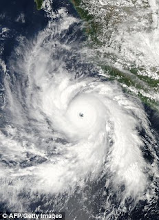 Hurricane Rick went into the record books over the weekend after it roared to the top of the Saffir-Simpson scale, going from a Category One storm to a Category Five monster in an astonishing 36 hours.
The storm is roaring roaring towards the popular tourist town of Cabo San Lucas on the Baja California Peninsula today. Its howling winds have been measured at 145mph - bringing it down to a dangerous Category Four storm. Over the weekend winds reached up to 180mph - a potentially catastrophic Category Five.
Forecasters said they expected Rick to make landfall by midweek as a Category 1 or Category 2 hurricane, with winds ranging from 74 mph (120 kph) to 110 mph (177 kph).
Forecasters called on all those in Mexico's southern Baja California peninsula and along the mainland coast to closely monitor the storm, adding Rick would remain an extremely dangerous hurricane for the next day or two before losing some punch over cooler waters.
As of 11 pm EDT Sunday (4am British time this morning), the eye was centered about 410 miles (660 kilometers) south of the peninsula town of Cabo San Lucas. The storm was moving toward the northwest near 13 mph (20 kph). (Daily Mail)
Wednesday, 30 September 2009
Up to 100 dead after tsunami strikes South Pacific coast
Up to 100 people are feared dead after a powerful undersea earthquake struck in the South Pacific between Samoa and American Samoa.
 Emergency services feared entire villages had been wiped out by the massive waves, which sent terrified residents fleeing for higher ground.
Latest news from American Samoa said the tsunami had killed at least 14 people there. In nearby Western Samoa, unconfirmed reports said that a further 40 people were believed to have died.
Fears of a devastating ocean-wide tsunami dissolved after the Pacific Tsunami Warning Center cancelled its warning for the region. The warning had been issued three and a half hours earlier after an 8.3 magnitude earthquake off American Samoa. The 2004 Asian tsunami killed about 230,000 people across 11 countries.
'I can confirm there is damage, I can confirm there are deaths and I can confirm there are casualties," a Western Samoa police spokeswoman said. "I cannot say any more at the moment.'
President Thomas Lapua, who lives in the Western Samoan capital of Apia, said: 'These are places that exist because people depend on the sea to fish - now the sea is threatening their lives. It may be some time before we find out the full extent of this.' (Daily Mail)
Tuesday, 29 September 2009
Typhoon Hits Vietnam As Death Toll Soars
Typhoon Ketsana has hit Vietnam's central coast - as the storm's death toll in the Philippines rose to 240.
 Ketsana was battering the Vietnamese province of Quang Nam with winds up to 90mph, unleashing floods and killing at least three people. The storm made landfall 37 miles south of Danang, according to the National Weather Centre. TV footage showed trees toppled onto roads and corrugated metal and other debris tossed around in the tourist hub - the country's fourth-largest city.
Provincial disaster official Nguyen Minh Tuan said two people in the province were killed by falling trees and another died after being struck by an electrical line. The typhoon was forecast to move west at about 12km/ph towards central Vietnam. Stormy weather in the past week has already killed 18 people in the area, including deaths from drowning, electrocution and accidents, an official said.
Over the weekend, Ketsana caused havoc in the Philippines as a weaker tropical storm. It dumped more than a month's worth of rain in just 12 hours, fuelling the worst flooding to hit the country in 40 years. Aside from a rising number of deaths after flash floods in and around capital city Manila, nearly 400,000 have been left homeless.Troops, police and volunteers have already rescued more than 12,359 people, but unconfirmed reports of more deaths abound, Philippine defence secretary Gilbert Teodoro said. (Sky News)
Saturday, 26 September 2009
Dust storm reaches northern NSW
A storm originating from South Australia has progressed to northern NSW, and is expected to reach Brisbane early on Saturday evening.
 An area of dust particles swept up in the storm measures up to 200km wide, Bureau of Meteorology (BoM) duty forecaster from Sydney, Jane Golding told AAP. The storm front reached Armidale about 3pm (AEST) on Saturday, and cleared the town half an hour later.
It is expected to reach Brisbane and Lord Howe Island about 7pm (AEST). As it continues its journey north the storm front was slowing down, Ms Golding said.
At 4pm (AEST) it was travelling at 50km/h.
"The further away from the source it gets, it loses a bit of dust," she added.
Some of the dust has been swept out to sea. The storm front passed through central western NSW late on Friday, and reached Sydney in the early hours of Saturday morning. By 8.30am (AEST) it had cleared metropolitan areas.
Visibility in Sydney was at 5000 metres, compared to 500 metres on Wednesday, when thick red dust blanketed the city. A BoM forecaster from Brisbane, Ben Annells, said the dust storm would arrive in Brisbane in two waves, both on Saturday evening. (Sydney Morning Herald)
Thursday, 24 September 2009
Visible from space: The wall of dust marching across the Australian outback to turn the skies over Sydney blood red
It is a city that usually wakes to brilliant blue skies. But dawn broke with a dramatic difference in Sydney yesterday. Pulling back their blinds, residents were greeted with an eerie reddish-orange cloud cloaking all around them.
 Early-morning commuters stared in disbelief at the Sydney Opera House and Harbour Bridge, whose normally striking outlines were rendered ghostly by the shroud of dust. The outback dust storm has swept across eastern Australia, shrouding Sydney in a dramatic red glow.
It's also been wreaking havoc, disrupting transport and placing health authorities on alert for widespread respiratory illness.
International flights were diverted from Sydney, ferries on the harbour were suspended, and motorists were warned to take care on roads as visibility was dramatically reduced. However, the eerie scenes haven't caused all activities to cease - the iconic Bondi beach still had its surfers and children continued to play on swings in the city's parks.
The storm, which blacked out the mining town of Broken Hill on Tuesday before sweeping east, was caused by a major cold front whipping up the dust from the drought-stricken hinterland. (Daily Mail)
Wednesday, 23 September 2009

Monday, 9 March 2009
Cyclone Hamish stalks central Queensland coast
 Cyclone Hamish evacuations have been put on hold amid predictions the weakening cyclone may hold its path parallel to the coast. Currently situated around 210km northeast of Yeppoon and travelling south at 10km/h, Hamish still poses a threat to exposed coastal and island communities between Yeppoon and Hervey Bay. However, an emergency services spokeswoman said all evacuations had been put on hold.Queensland Premier Anna Bligh has warned resident in low-lying areas to be prepared for flooding. "Some places like Hervey Bay are particularly low-lying and, therefore, have considerable higher risk," Ms Bligh told Channel 9."Good news overnight that we've seen a slight movement in the tracking for this cyclone, the prospect of it crossing the coast is a little less than it was yesterday."But ... these are very unpredictable events and they can change at short notice and we're monitoring it very carefully." (news.com.au)
Saturday, 7 March 2009
Hamish's winds to batter North Queensland coast
Destructive winds will pick up tonight along the north Queensland coast as Severe Tropical Cyclone Hamish edges closer. It is expected to stay out at sea but its effects will be felt on land, and residents have been preparing for much of the day for Hamish's arrival.
 Those preparations will be tested within hours, as the Category 4 cyclone is expected to move past the Whitsundays early tomorrow morning. Forecaster Bruce Gunn says they expect destructive wind gusts of up to 165 kilometres an hour.
"The winds will steadily pick up over the coming hours and people should be really putting their cyclone plans into action," he said.
Bruce Grady from Emergency Management Queensland says they are keeping a very close eye on islands in the Whitsundays.
He says the cyclone's winds will be strongest out to sea around the islands."South Molle Island for example has taken the decision to evacuate, but other islands have very sound infrastructure and well developed emergency plans," he said."It's considered safer to keep the people in-situ on those islands."
Residents in low lying areas around Mackay are being advised to find higher ground tonight. Authorities are concerned a storm surge combined with heavy rain and a high tide in the morning could flood many areas. (ABC.net.au)
Subscribe to:
Posts (Atom)